Plik:Aral Sea.jpg
Rozmiar pierwotny (2682 × 1780 pikseli, rozmiar pliku: 2,82 MB, typ MIME: image/jpeg)
Opis
| Opis |
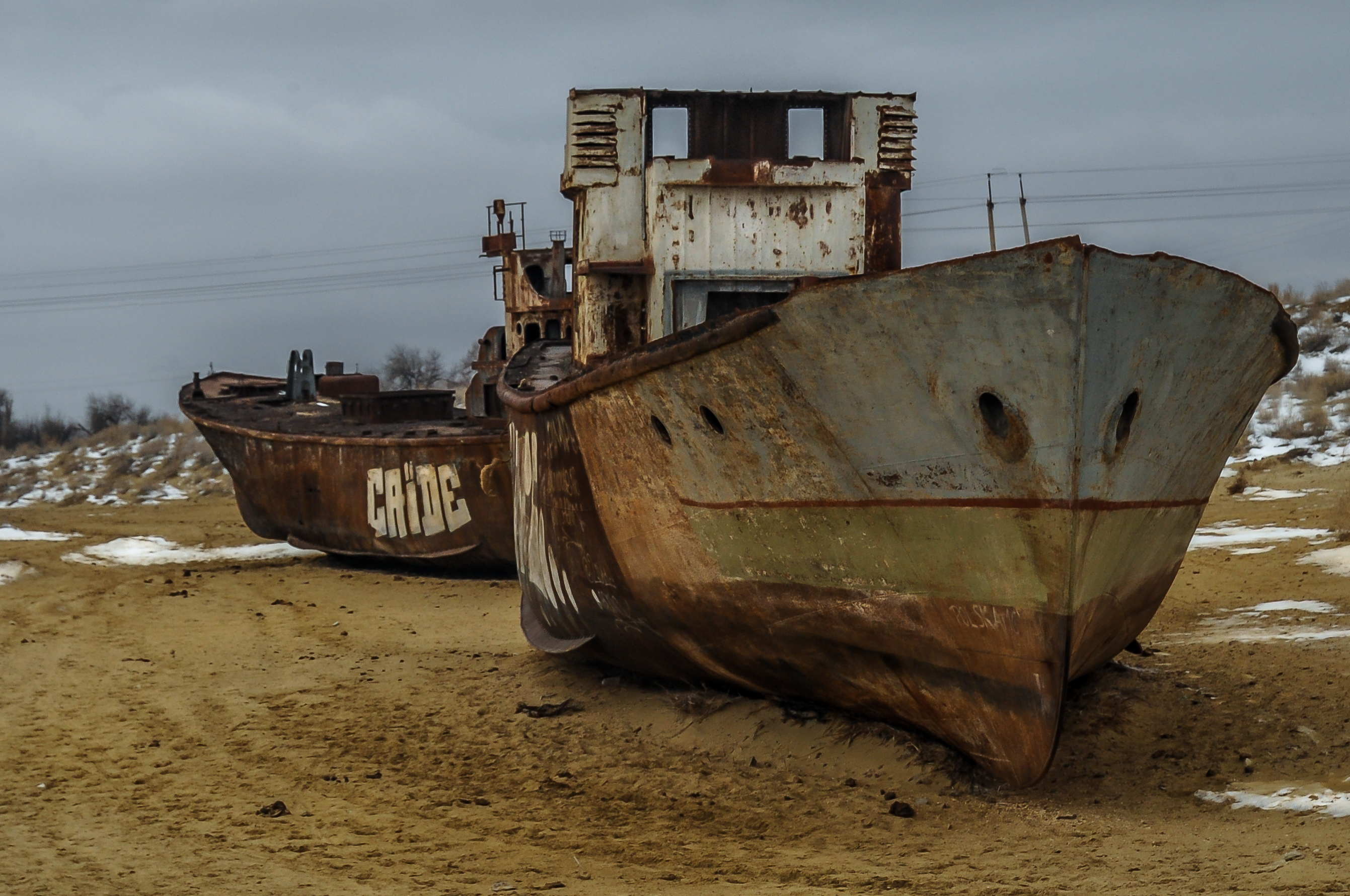
English: The Aral Sea is located in Central Asia between Kazakhstan and Uzbekistan. It is actually a lake, but because the water inside is salty like the ocean, it was called a sea. It used to be the 4th largest lake in the world, but has been shrinking for over 40 years because farmers were taking a lot of water from the lake to bring to their cotton fields. Now, there is almost nothing left of the lake. As the water has gone down, the amount of salt in the water has increased making it too salty for many plants, fish, and animals to live there anymore. Many fish, plants, and animals have died because the water is too salty. To make matters worse, the government, farmers, and other people have been dumping garbage and harmful chemicals in the Aral Sea and the area around it. This means that people living close to the Aral Sea are much more likely to get sick. People living there have 9 times the rate of cancer as other people in their countries. |
| Data | |
| Źródło | Praca własna |
| Autor | Ecpirolli |
The Aral Sea is located in the central Asian countries of Uzbekistan and Kazakhstan. Once the world's fourth largest lake, the mighty Aral Sea is now almost gone. The sea has been shrinking for the last 40 years.
The Aral Sea is an inland salt-water sea with no outlet. It is fed by two rivers, the Amu Darya and Syr Darya. The fresh water from these two rivers held the Aral's water and salt levels in perfect balance.
Then, in the early 1960's, the Soviet government decided to make the Soviet Union a large exporter of cotton. Large dams were built across both rivers and many smaller canals were created to water the cotton fields. Over the next 30 years, the Aral Sea experienced a severe drop in water level, its shoreline receded, and its salt content increased. The marine environment became so salty and polluted; it killed many of the Aral Sea’s plants and animals. As the marine life died, the fishing industry suffered.
By 1990, as a result of the continuing water diversion, the shrinking Aral Sea divided in two and its salinity increased from 10 grams (2 tsp) per litre to 45 (9 tsp). In some parts of the south Aral, salinity tops out at 98 g (19.6 tsp) per litre as of 2001. Average seawater salinity is 33 g (6.6 tsp) per litre. The once thriving fishing industry has been destroyed along with the fish and most of the flora and fauna. Salt pans and contaminated runoff lakes have appeared, and winters have become harsher and longer, summers hotter and shorter.
Today, towns that used to be fishing towns are now desert towns more than 50 miles from the Aral Sea. Ships were left to rot in the sand. The sea has shrunk to two-fifths of its original size and now ranks about 10th in the world. The water level has dropped by 52 feet and the volume has been reduced by 75 percent, a loss equivalent to the water in both Lakes Erie and Huron.
The ecological effect has been disastrous and the economic, social and medical problems for people in the region catastrophic. The cotton fields flourished, but farmers had to use massive amounts of chemical pesticides. Of the region's 73 species of birds, 70 of mammals and 24 of fish, most have either perished or moved on. Roughly 20 fish species in the Aral Sea are now extinct, unable to survive the toxic, salty sludge. Drinking water supplies have dwindled, and the water is contaminated with pesticides and other agricultural chemicals as well as bacteria and viruses.
The area is now constantly subject to toxic duststorms and desertification, the people of the area have 9 times the world average rate for throat cancer, and infant/maternity mortality is the highest in all of the former Soviet Union's republics. Respiratory complications, tuberculosis and eye diseases are also rising alarmingly.
The Uzbek government has little concern for the Aral Sea, so the southern portion will mostly likely completely disappear in a few years. The Kazakh government has implemented some policies to try to protect the Aral Sea, so the northern part may stand a chance.
Licencja
- Wolno:
- dzielić się – kopiować, rozpowszechniać, odtwarzać i wykonywać utwór
- modyfikować – tworzyć utwory zależne
- Na następujących warunkach:
- uznanie autorstwa – musisz określić autorstwo utworu, podać link do licencji, a także wskazać czy utwór został zmieniony. Możesz to zrobić w każdy rozsądny sposób, o ile nie będzie to sugerować, że licencjodawca popiera Ciebie lub Twoje użycie utworu.
| This image was uploaded as part of Wiki Science Competition 2017. |
Historia pliku
Kliknij na datę/czas, aby zobaczyć, jak plik wyglądał w tym czasie.
| Data i czas | Miniatura | Wymiary | Użytkownik | Opis | |
|---|---|---|---|---|---|
| aktualny | 23:52, 6 lis 2017 | | 2682 × 1780 (2,82 MB) | Ecpirolli | User created page with UploadWizard |
Lokalne wykorzystanie pliku
Poniższa strona korzysta z tego pliku:
Globalne wykorzystanie pliku
Ten plik jest wykorzystywany także w innych projektach wiki:
- Wykorzystanie na en.wikipedia.org
- Wykorzystanie na simple.wikipedia.org