Plik:Shanghai1907.jpg

Rozmiar pierwotny (1104 × 742 pikseli, rozmiar pliku: 151 KB, typ MIME: image/jpeg)
Opis
| Opis |
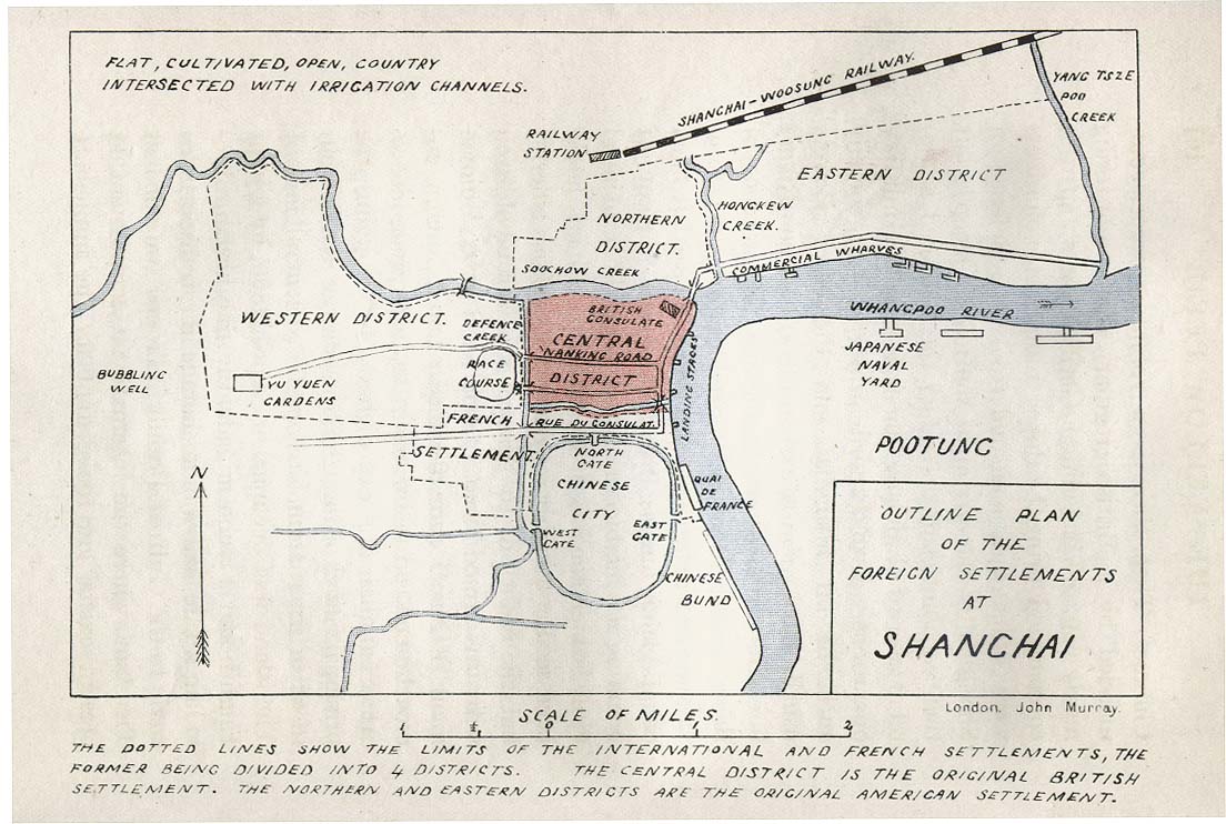
English: "Outline of the Plan of the Foreign Settlements at Shanghai", from Col. A. M. Murray's Imperial Outposts, from a Strategical and Commercial Aspect, with Special Reference to the Japanese Alliance. Published by John Murray (London), 1907. |
| Data | 27 marca 2011 (data pierwszego przesłania pliku) |
| Źródło |
http://www.lib.utexas.edu/maps/historical/shanghai_1907.jpg " I would like to use one of your historical maps http://www.lib.utexas.edu/maps/historical/shanghai_1907.jpg in the Wikivoyage (Wikivoyage.org) article on Shanghai. They require that anything uploaded be released under their Creative Commons 3.0 license. I have read your usage statement and it appears to me that this map is in the public domain so I can do that. However, I thought I'd better check. Their reply: " Thank you for your interest in the University of Texas Libraries' Map Collection. Unless marked otherwise, the maps scanned by the University Libraries are in the public domain. The map images are not copyrighted and no permission is needed to copy them. You may download them and use them as you wish. We do appreciate hearing from you about your use of these materials and we also appreciate you giving this site credit. Appropriate credit for public domain materials would be: "Courtesy of the University Libraries, The University of Texas at Austin."
|
| Autor | John Murray |
Licencja
| Ten utwór został udostępniony jako własność publiczna przez jego autora, www.lib.utexas.edu. Dotyczy to całego świata. W niektórych krajach może nie być to prawnie możliwe, jeśli tak, to: www.lib.utexas.edu zapewnia każdemu prawo do użycia tej pracy w dowolnym celu, bez żadnych ograniczeń, chyba że te ograniczenia są wymagane przez prawo.
|
Oryginalny rejestr przesyłania
| This file was imported from Wikivoyage WTS. |
- 2011-03-27 02:37 (WT-shared) Pashley 1104×742 (154734 bytes) Map is from the collection at U of Texas. I emailed them to ask about this: " I would like to use one of your historical maps http://www.li (Import from wikitravel.org/shared)
Historia pliku
Kliknij na datę/czas, aby zobaczyć, jak plik wyglądał w tym czasie.
| Data i czas | Miniatura | Wymiary | Użytkownik | Opis | |
|---|---|---|---|---|---|
| aktualny | 20:15, 3 maj 2013 | | 1104 × 742 (151 KB) | MGA73bot2 | {{BotMoveToCommons|wts.oldwikivoyage|year={{subst:CURRENTYEAR}}|month={{subst:CURRENTMONTHNAME}}|day={{subst:CURRENTDAY}}}} == {{int:filedesc}} == {{Information |description=Map is from the collection at U of Texas. I emailed them to ask about this: "... |
Lokalne wykorzystanie pliku
Poniższa strona korzysta z tego pliku:
Globalne wykorzystanie pliku
Ten plik jest wykorzystywany także w innych projektach wiki:
- Wykorzystanie na en.wikivoyage.org