Plik:Kasbah des Oudaias (5509115774).jpg

Rozmiar pierwotny (2848 × 4288 pikseli, rozmiar pliku: 3,34 MB, typ MIME: image/jpeg)
.jpg)
Opis
| Opis |
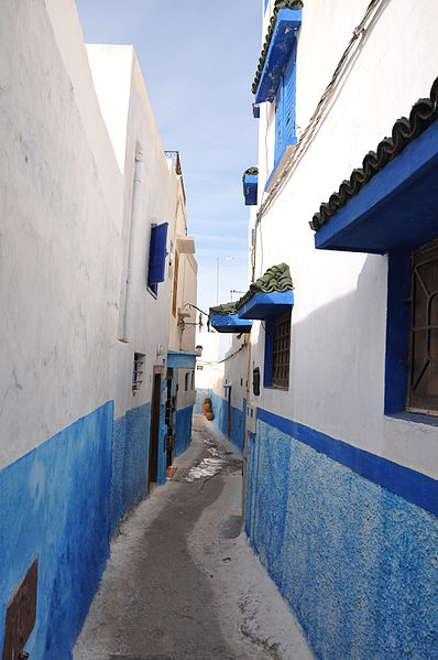
The Kasbah des Oudaias is located in Rabat, the capital of Morocco, which is situated near to the Atlantic coast. Like most other cities in Morocco, Rabat is old and has a lot of historical value. But what makes Rabat different in comparison to other cities is the section of the city called Kasbah des Oudaias. The Kasbah des Oudaias is a picturesque place with houses and streets that are of a different standard to the rest of the city. All the houses are white and look like they have just been painted with bright blue parapets. The Kasbah des Oudaias provides you with the most amazing views of the Atlantic Ocean and of Sale, Rabat's neighboring city. This part of city is quiet and there are relatively few people walking around the maze of streets. This makes exploring the northern parts of the city a lot more fun. Located in the vicinity of Kasbah des Oudaia is the oldest mosque in the capital, namely the Kasbah Mosque. The mosque was built in the mid-eleventh century and the beautiful gateway (Bab Oudaia) that leads you to the Kasbah was built in the twelfth century. The mosque was enlarged and renovated later in the eighteenth century. The busiest parts of Kasbah des Oudaia are the beaches, where you can sit and watch the ocean waves as they come in and hit the Kasbah walls for hours. Hundreds of people from outside of Morocco come to Kasbah des Oudaia because of its shoreline and its picturesque views. You will notice that there is quite a bit of repair work being done on the old buildings and houses near the beach. [morocco.com] The Kasbah of the Udayas is a kasbah in Rabat, Morocco. It was built during the reign of the Almohads. When the Almohads had captured Rabat and destroyed the kasbah of the Almoravids in the town, they began reconstructing it in AH 544 / AD 1150. They added a palace and a mosque and named it al-Mahdiyya, after their ancestor al-Mahdi Ibn Tumart. After the death of Yaqub al-Mansur (AH 595 / AD 1199) the kasbah was deserted. [Wikipedia.org] |
| Data | |
| Źródło | Kasbah des Oudaias |
| Autor | Jorge Láscar from Australia |
| Pozycja fotografa | | To i inne zdjęcia na: OpenStreetMap |
|---|
.jpg¶ms=034.031808_N_-006.836097_E_globe:Earth_type:camera_source:Flickr_&language=pl)
Licencja
- Wolno:
- dzielić się – kopiować, rozpowszechniać, odtwarzać i wykonywać utwór
- modyfikować – tworzyć utwory zależne
- Na następujących warunkach:
- uznanie autorstwa – musisz określić autorstwo utworu, podać link do licencji, a także wskazać czy utwór został zmieniony. Możesz to zrobić w każdy rozsądny sposób, o ile nie będzie to sugerować, że licencjodawca popiera Ciebie lub Twoje użycie utworu.
| Ten plik, opublikowany pierwotnie w serwisie Flickr, został przejrzany 3 kwietnia 2014 przez administratora lub zaufanego użytkownika Denniss, który stwierdził, że jest on dostępny w serwisie Flickr pod powyższą licencją. |
Historia pliku
Kliknij na datę/czas, aby zobaczyć, jak plik wyglądał w tym czasie.
| Data i czas | Miniatura | Wymiary | Użytkownik | Opis | |
|---|---|---|---|---|---|
| aktualny | 14:51, 2 kwi 2014 | | 2848 × 4288 (3,34 MB) | Rotatebot | Bot: Image rotated by 0° (EXIF-Orientation set from 8 to 1, rotated 270°) |
| 09:44, 2 kwi 2014 |  | 2848 × 4288 (3,34 MB) | Russavia | Transferred from Flickr |
Lokalne wykorzystanie pliku
Poniższa strona korzysta z tego pliku:
Globalne wykorzystanie pliku
Ten plik jest wykorzystywany także w innych projektach wiki:
- Wykorzystanie na en.wikivoyage.org
.jpg)